AI in Environmental Monitoring 2026: Protecting Our Planet
AI in Environmental Monitoring 2026: Protecting Our Planet
AI environmental monitoring has emerged as one of the most consequential applications of artificial intelligence — not because the technology is flashy, but because the problems it's addressing are urgent. In 2026, AI systems are tracking deforestation in near real-time, monitoring air and water quality across networks of distributed sensors, detecting illegal fishing vessels by analyzing satellite imagery, and helping scientists understand biodiversity loss at a scale that would be impossible with traditional methods.
The technology is not the story. What matters is what it's doing with that technology.
Why Environmental Monitoring Needed AI
Environmental science has always been a data problem. Ecosystems are complex, distributed, and dynamic. Manual monitoring is expensive, slow, and spatially limited. A team of researchers can monitor a forest plot; they cannot monitor a continent.
The data scale of modern environmental monitoring is staggering:
- Sentinel satellites from the European Space Agency generate terabytes of imagery daily
- Ocean buoy networks produce continuous streams of temperature, salinity, and pH readings
- Acoustic sensors in forests record thousands of hours of soundscape data per week
- Air quality sensor networks in cities generate millions of readings per day
Without AI, most of this data goes underanalyzed. Pattern recognition at this scale requires machine learning. AI doesn't replace environmental scientists — it gives them the analytical capacity to actually use the data they're already collecting.
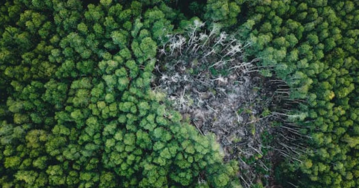
Satellite AI for Deforestation and Land Use
Tracking deforestation was once a months-long exercise in manual image analysis. AI has reduced that to near real-time alerts.
Global Forest Watch (operated by the World Resources Institute) uses AI to analyze satellite imagery and flag forest loss within days of it occurring. The system distinguishes between fire, logging, and agricultural clearing — context that matters for understanding drivers and identifying illegal activity. Global Forest Watch data is freely available and has been used by governments, NGOs, and journalists to document environmental crimes. (globalforestwatch.org)
Planet Labs operates a constellation of small satellites that image the entire land surface of Earth daily. Their AI layer processes this imagery to detect changes — not just forest loss but construction activity, mining operations, crop disease, and flood extent. The temporal resolution is what makes this powerful: you can watch a coral reef bleaching event unfold in daily frames.
Carbon credit verification is an emerging application. AI analysis of satellite imagery can verify whether forest carbon offset projects are actually maintaining the forest coverage they claim — a significant problem in the voluntary carbon market. See AI for Carbon Credit Verification in 2026: How It Works for more detail on this specific application.
AI for Air Quality and Pollution Monitoring
Air quality monitoring has historically been constrained by the cost of regulatory-grade monitoring stations, which run $100,000 or more per unit. This has meant significant gaps in coverage, especially in lower-income countries and communities.
AI is addressing this in two ways:
Low-cost sensor networks with AI calibration — Cheaper sensors produce noisier data, but AI models trained on data from co-located regulatory-grade sensors can calibrate low-cost sensor readings to acceptable accuracy. This makes dense, city-wide air quality monitoring affordable.
AI air quality forecasting — Models from Google DeepMind and several national meteorological agencies now produce localized air quality forecasts 24-72 hours out. These combine atmospheric physics models with ML-based pattern recognition, producing more accurate predictions than physics-only approaches.
Cities using AI air quality systems are using the data to inform decisions like school outdoor activity restrictions, traffic routing during high-pollution events, and targeting of emission reduction policies.
AI for Ocean and Water Monitoring
Oceans cover 71% of Earth's surface and remain dramatically undermonitored. AI is expanding the reach of ocean observation.
Argo float networks — Thousands of autonomous floats drift through the world's oceans, profiling temperature, salinity, and dissolved oxygen at depth. AI models process this data to produce ocean state estimates and detect anomalies like marine heat waves.
Acoustic monitoring for whale populations — Machine learning classifiers analyze hydrophone recordings to identify whale species, track migration patterns, and detect anomalous vocalizations. The National Oceanic and Atmospheric Administration (NOAA) has been deploying AI-based marine mammal monitoring in several ocean basins.
Satellite altimetry and sea surface temperature — AI models process satellite-derived ocean surface data to track El Niño events, predict coral bleaching risk, and monitor sea level changes at regional scales.
Freshwater quality — AI systems integrated with sensor networks on rivers and reservoirs detect pollution events in real time, triggering alerts before contaminated water reaches drinking water intakes.
AI for Biodiversity and Wildlife Monitoring
Understanding where species are, how many exist, and whether populations are stable requires monitoring at scales that exceed what traditional field surveys can achieve.
Camera trap AI — Wildlife monitoring via camera traps generates millions of images annually. AI models now classify animals in these images automatically, eliminating the bottleneck of manual image review. Tools like Wildlife Insights (a Google and Smithsonian collaboration) provide free AI classification for camera trap images, with accuracy comparable to trained human reviewers for common species.
Bioacoustics AI — Acoustic monitoring uses machine learning to identify species by sound. The BirdNET neural network, developed by the Cornell Lab of Ornithology, can identify over 6,000 bird species by call. Citizen scientists deploy this at scale through apps like Merlin. At the research level, acoustic monitoring networks are producing continent-scale bird population estimates.
eDNA analysis — Environmental DNA (fragments of genetic material shed by organisms into water or soil) can be analyzed to detect species presence without requiring visual observation. AI accelerates the genomic analysis pipeline, making eDNA surveys faster and more cost-effective.
Climate Modeling and Prediction
AI is beginning to reshape climate modeling, though this is a domain where hype exceeds current reality.
What AI is genuinely doing in climate science:
- Emulating expensive physical simulations — AI models trained on runs from physics-based climate models can approximate their outputs in a fraction of the compute time, enabling larger ensembles and sensitivity analyses
- Improving precipitation and weather prediction — Models like Google's GraphCast have demonstrated better short-term forecast accuracy than traditional numerical weather prediction for some variables
- Downscaling — Converting coarse global climate model outputs to high-resolution regional projections, which is necessary for infrastructure planning and adaptation decisions
What AI is not doing: generating independent climate projections from first principles. AI climate models depend on training data from physics-based simulations and observational records. They're tools for extending and accelerating physical modeling, not replacements for it.
Challenges and Limitations
AI environmental monitoring faces real constraints:
- Data gaps in the Global South — Satellite coverage is global, but ground-truth data for model training is heavily concentrated in North America, Europe, and East Asia. AI models may perform worse in regions with less training data.
- Interpretability — Black-box models are problematic when monitoring data is used for regulatory enforcement or legal proceedings. Methods like SHAP and LIME help, but interpretability remains a limitation.
- Latency between detection and action — Detecting deforestation quickly is only valuable if detection triggers a timely enforcement response. Technical systems are often ahead of institutional capacity.
- Energy consumption — AI systems themselves have significant computational energy demands. The net environmental benefit of AI monitoring requires honest accounting of these costs.
For a broader view of how AI is addressing climate challenges, see AI and Climate Change 2026: How AI Is Helping Fight Global Warming.
AI environmental monitoring is one of those applications where the stakes are high enough that it warrants serious attention and investment. The tools exist. The data exists. The limiting factor is often institutional will and resources to act on what the AI is revealing.
Comments
Loading comments...